Solar eclipse map: Where to see the total eclipse
 Doyle Rice
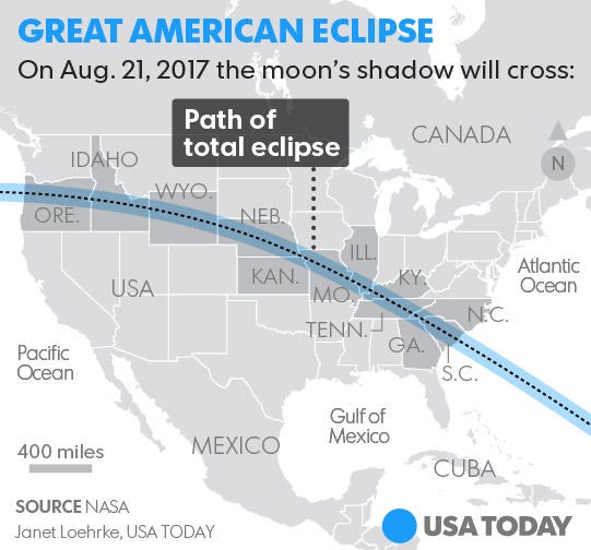
Starting on the West Coast in Oregon, the USA's total solar eclipse on Aug. 21 will trace a 67-mile wide path east across the country, finally exiting the East Coast in South Carolina.
The "path of totality," in which the moon's shadow sweeps across the Earth's surface, will cross parts of 12 states: Oregon, Idaho, Wyoming, Nebraska, Kansas, Missouri, Illinois, Kentucky, Tennessee, Georgia, North Carolina and South Carolina.
The total eclipse begins in Oregon at 10:16 a.m. PDT. (To be the first person on land to see the eclipse, be on the waterfront at Government Point, Ore., at 10:15:56.5 a.m. PDT.) It will end near Charleston, S.C., at 2:48 p.m. EDT.
In any given location, the total eclipse will last about 2 or 3 minutes. It will take about an hour and a half for the eclipse to move across the entire country.
Some of the larger cities directly in the path include Nashville, Tenn.; and Greenville, Columbia and Charleston in South Carolina. Both Kansas City and St. Louis, Mo., are barely outside the path, though parts of the cities' metropolitan areas will see the total eclipse.
Smaller towns in the path include Salem, Ore.; Idaho Falls, Idaho; Casper, Wyo.; Grand Island and Lincoln, Neb.; St. Joseph and Columbia, Mo.; Bowling Green, Ky.,; Clarksville and Murfreesboro, Tenn.; and Anderson, S.C.